Weather research UAVs take flight at OSU
Tuesday, July 12, 2016
In the first face-to-face meeting of four university partners in a project to develop unmanned aerial systems for weather research, more than 65 faculty and students met at Oklahoma State University to discuss project goals, but more importantly to kick the tires of unmanned aerial vehicles in test flights for the NSF CLOUD-MAP project.
NSF CLOUD-MAP (Collaboration Leading Operational UAS Development for Meteorology and Atmospheric Physics) is an alliance of OSU, the University of Oklahoma, the University of Kentucky and the University of Nebraska. In 2015, the four, with OSU as the lead university, received a National Science Foundation four-year, $6 million grant to develop UAV systems to improve atmospheric research and weather forecasting, including providing earlier and more accurate severe weather warnings.
“CLOUD-MAP will allow meteorologists and atmospheric scientists to use unmanned aircraft as a common, everyday tool,” said Jamey Jacob, the project’s lead investigator and a professor of mechanical and aerospace engineering at OSU. Jacob is the director of OSU’s recently formed Unmanned Systems Research Institute. “Affordable, robust unmanned systems will make collecting atmospheric data in the lower atmosphere practical.”
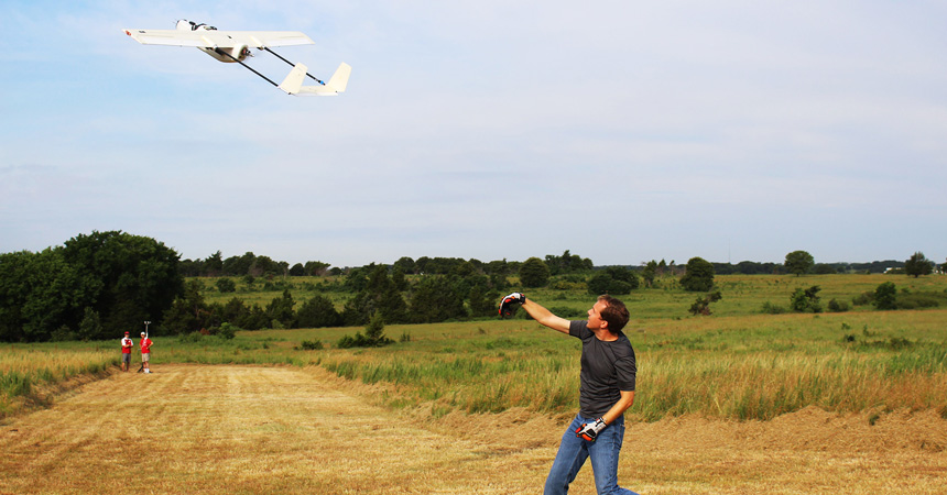
Researchers from three universities traveled to Stillwater in June to join their OSU counterparts to test the capabilities of unmanned aircraft to collect weather data. An important area of testing included the instruments carried by UAVs for collecting atmospheric information. According to Jacob, the potential for flying UAVs packed with instruments is the ability to reach an area of the atmosphere where most weather events form and where current weather-monitoring technologies, like radar or ground-based weather stations, can’t accurately collect information.
“The resulting data collected during this meeting of the CLOUD-MAP universities is valuable in increasing our understanding of how unmanned aircraft can be used regularly in the boundary layer,” Jacob said.
The meeting also gave researchers a chance to meet and compare UAV systems that each university has developed. That face-to-face collaboration was eye-opening, said one visiting researcher.
“I think meeting has been amazing and created spontaneous sharing of ideas,” said Suzanne Weaver Smith, professor of mechanical engineering and director of the University of Kentucky Unmanned Systems Research Consortium. “The creativity it will create is going to be stunning.”
One goal of field testing UAVs was gauging the ability of aircraft to be flown day in and day out. CLOUD-MAP partners, who brought more than a dozen aircraft to Stillwater, flew UAVs at OSU’s unmanned aircraft test field and at an Oklahoma Mesonet weather station west of Stillwater where conditions were more challenging without flight-friendly amenities like a runway. Flying from the weather station also allowed researchers to compare data collected by UAVs with that from ground-based instruments.
The partners made nearly 250 flights over a three-day period. Jacob said one of the week’s most important goals was demonstration of robust repeatable flights and autonomous multi-vehicle operation. Other goals included assessing data accuracy. Those goals were met, he said.
Four universities working together to tackle a vital need is a promising approach to large research projects. Academic research often means universities closely guarding data until research is published. “Openness creates opportunities,” said Weaver Smith.
“A special thing about this is people are open about sharing their work and are collaborative minded,” she said. “That’s a very unique situation.”
Meetings of the CLOUD-MAP partners will be held annually, said Jacob. “This first meeting allows us to set a baseline for where our current technologies are and how they work together,” he said. “Ultimately, this project will save lives and property by improving our understanding of the atmosphere and developing more accurate forecasting models.”
To learn more visit http://www.cloud-map.org/.
PHOTOS: https://www.flickr.com/photos/ostatenews/albums/72157670298961131