
OSU project aims to strengthen ocean threat detection
Friday, June 12, 2026
Media Contact: Desa James | Communications Coordinator | 405 744 2669 | desa.james@okstate.edu
The ocean is vast and increasingly difficult to monitor.
From illegal trafficking operations to threats against offshore infrastructure, the challenge of keeping watch over hundreds of thousands of square miles has outgrown what traditional surveillance methods can realistically handle.
Dr. Baski Balasundaram from the School of Industrial Engineering and Management in the College of Engineering, Architecture and Technology is developing a mathematical optimization framework designed to help improve persistent maritime surveillance using fleets of unmanned surface vehicles that support national security and critical infrastructure protection.

The project addresses a growing operational challenge: monitoring expansive ocean regions. Traditional crewed ships and aircraft alone are often unable to sustain continuous coverage across areas spanning hundreds of thousands of square miles.
Balasundaram, in collaboration with Dr. Juan Borrero of the University of South Florida, is conducting research to improve how autonomous maritime systems detect and respond to suspicious activity over extended periods.
“Persistent maritime surveillance is challenging,” Balasundaram said. “The gap between the surveillance needs and what conventional platforms alone can deliver keeps widening, which is why persistent, low-cost, long-duration coverage has become a pressing operational priority.”
USVs are autonomous vessels capable of operating for months at sea using solar, wind and wave energy. Equipped with sensors and communication systems, they can gather and transmit real-time environmental and surveillance data while reducing the need to place crews in potentially dangerous situations.
While the technology behind USVs continues to advance, the researchers say there are few existing models that address how to efficiently allocate limited response resources once suspicious activity is identified.
The Oklahoma State University-led project seeks to close that gap by developing an optimization framework to help command centers determine which potential threats should receive immediate attention and how to deploy limited interdiction resources — such as aerial units or patrol vessels.
“Our framework rethinks maritime surveillance as a coordinated network problem rather than a collection of independent sightings,” Balasundaram said.
To explain the concept, Balasundaram compares the system to a large neighborhood watch operating across the ocean. Rather than treating each alert independently, the framework analyzes how patterns evolve across multiple vehicles and over time to determine whether activity represents a credible threat or a false alarm.
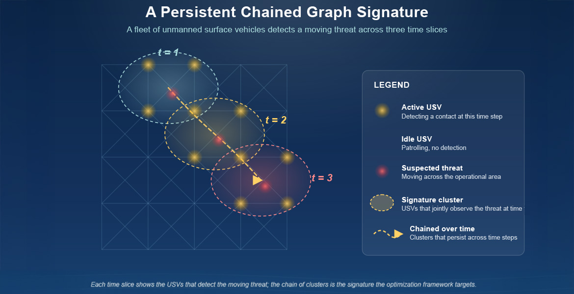
The project models USV fleets as “temporal networks,” allowing researchers to study how communication, sensor coverage and vessel movement change moment by moment. Using tools from graph theory, mixed-integer programming and robust optimization, the team aims to identify what researchers call “persistent chained graph signatures” or recurring patterns of activity that remain consistent across multiple vehicles and multiple time periods.
“A single USV reporting a suspicious contact at a single moment is weak evidence,” Balasundaram said. “Our framework treats an alert as worth escalating only when the underlying signature is corroborated across multiple USVs and across time.”
The approach is designed to help reduce false positives while ensuring that significant threats are not overlooked.
The research team believes the framework could eventually support a wide range of maritime security operations, including monitoring for unauthorized vessels or submarines, illegal fishing, human trafficking, environmental violations and threats to offshore infrastructure such as pipelines, wind farms and drilling platforms.
Beyond its national security applications, the project also provides opportunities for OSU students to engage in advanced research at the intersection of optimization, data-driven decision-making and real-world operational systems.
Graduate students and undergraduate researchers involved in the project will gain experience in mathematical optimization, algorithm development, graph theory and temporal network analysis, while also learning to tackle complex operational problems with practical decision-making tools.
“The intersection of mathematical modeling, optimization and decision-making under limited resources and uncertainty is at the heart of industrial engineering and operations research,” Balasundaram said. “This project channels those strengths into a high-impact application while continuing our tradition of training students to solve complex systems problems that blend theory, computation and real-world practice.”
The ultimate goal of this work is to develop deployable planning tools that help Navy command centers process live data from fleets of autonomous vehicles and make informed real-time decisions.
At its core, the project reflects a broader mission shared across CEAT: applying rigorous engineering and analytical thinking to problems that affect safety, infrastructure and communities far beyond campus.