CIVE researchers looking to modernize state's culvert inventory
Tuesday, June 24, 2025
Media Contact: Tanner Holubar | Communications Specialist | 405-744-2065 | tanner.holubar@okstate.edu
Researchers in the College of Engineering, Architecture and Technology at Oklahoma State University are partnering with the University of Oklahoma in an effort to revamp the state’s culvert inventory database.
Funded by the Southern Plains Transportation Center, this project will utilize remote sensing and machine learning to improve climate resilience and aquatic connectivity of Oklahoma’s culverts.
Dr. Jaime Schussler, assistant professor in the School of Civil and Environmental Engineering, is the lead investigator on the project and has partnered with Dr. Thomas Neeson, an associate professor in the Department of Geography and Environmental Sustainability at OU.
In a previous SPTC project, Schussler’s team developed a culvert database with over 8,000 sites. Of these, only 16% were built within the past 15-25 years, while 61% were more than 50 years old- a testament to our aging infrastructure. The culverts in the original database represented approximately 19% of the total estimated number in the state. Dr. Schussler describes culverts as one element of our “hidden” infrastructure, which hides beneath the surface at road-stream intersections. They provide many of us with transportation connectivity every day, but are often unnoticed.
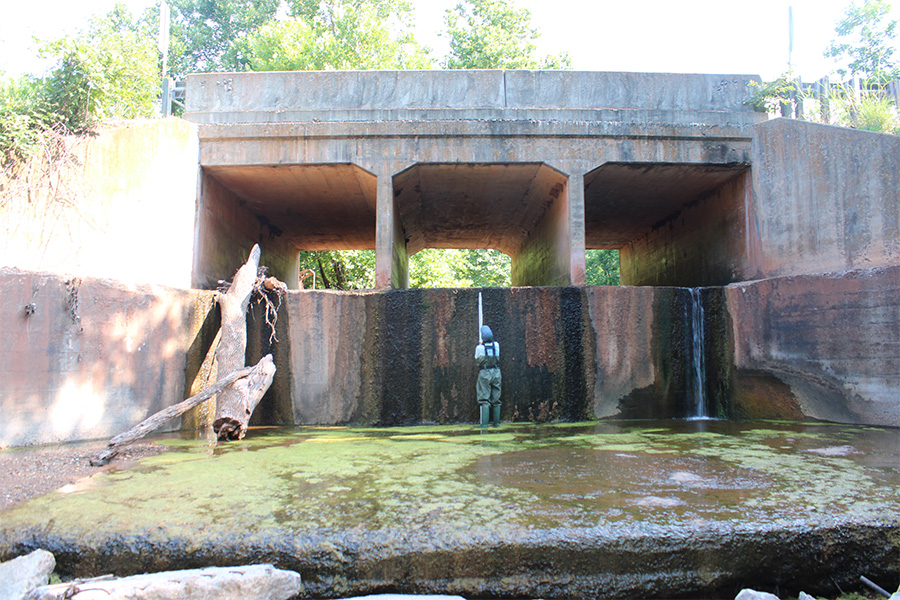
The culverts included in the database represented only the largest, engineered structures on the transportation system. However, smaller culverts, especially those in rural or remote areas, could be more susceptible to failure, such as washout, due to changing flow patterns in the stream, lack of regular inspection and maintenance due to their size, level of service, and location. Schussler says that “When culverts fail, it can be catastrophic. It could wash out a person’s driveway, inhibiting them from getting to work, the grocery store, school pick up, but it could also wash out an entire road, causing impacts at the community scale.”
Schussler emphasizes the necessity of having one comprehensive database categorizing the location and condition of Oklahoma's culverts. While culverts provide transportation connectivity, they can alter stream patterns and fragment aquatic habitats. There are strategies at road-stream crossings to minimize the impact on streams and the aquatic species that inhabit them; however, Schussler states that there is a need to prioritize culvert locations for these retrofits. Schussler hopes their data can help with this.
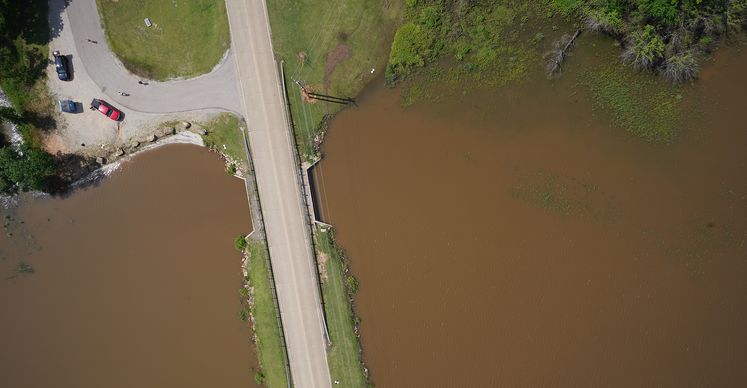
Remote sensing involves gathering data on a structure from a distance, such as using satellite imaging or using a drone to take aerial images for a method known as photogrammetry.
This involves taking thousands of photos of an area and piecing them together to create a photorealistic model of the area. Researchers can then study this 3D model without having to be directly on-site at that location. This minimizes the time and safety risks of conducting in-stream surveying at the road-stream intersections. Schussler and Neeson’s team will also use publicly available LiDAR data from the Oklahoma GIS Clearinghouse and compare it with the culvert database to complement statistical models.
Schussler’s previous efforts included using the database to train machine learning models to identify what characteristics may lead to susceptibility, and this project intends to build on this. Characteristics such as flow, length, constriction ratio and slope are being considered.
These models will then be used to make recommendations to improve the inspection, maintenance, and replacements of these culverts. Aging culverts could then be prioritized to be inspected and repaired.
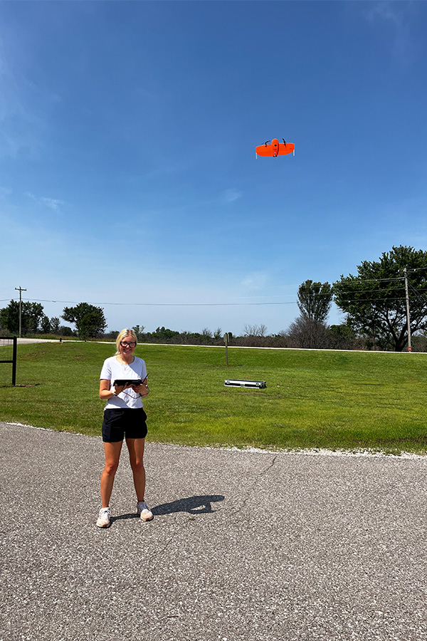
These remote sensing methods will also improve the safety of workers maintaining the culverts, as well as those working to map them. Many of the more remote culverts are dangerous and difficult to get to because of being in unmaintained areas.
It will also simplify analyzing the status of culverts in Oklahoma.
“It took us about 40 minutes per site to inspect a singular culvert during our previous project, either in the stream or on the road- during Oklahoma’s hot summer months,” Schussler said. “If we can fly a drone over it, grab some pictures, run it through a machine learning model, then we could really reduce the inspection time. The model would ideally be able to differentiate the dimensions of the culvert. Some of those factors will let us know how susceptible a culvert might be to failure and what the consequences of that failure could be.”
Schussler and Neeson will work with the Oklahoma Aquatic Connectivity Team and the Southeast Aquatic Resources Partnership and suggest improvements to culvert inspection protocols.
They will also work with the Oklahoma Department of Wildlife Conservation to discuss nature-based culvert designs to help aquatic life move through these culverts.
One comprehensive database would also benefit different state agencies to communicate and collaborate on culvert sites, such as transportation and conservation agencies, which may have other priorities regarding culvert maintenance.
“Infrastructure and conservation agencies may have their own priorities when considering retrofit or replacing these structures,” Schussler said. “A transportation agency is likely going to be focused on the level of serviceability, annual daily traffic, travel times, and such; whereas a conservation agency may be looking at migrating species, richness, and abundance. They may be looking at the same site through different lenses. So, if we can bring this comprehensive dataset, there may be potential for holistic understanding and inter-agency partnerships to reach multiple goals and optimize return on investment for culvert retrofits and replacements.”