OSU's powerhouse program aims to fly drones into more areas
Thursday, May 14, 2020
Every university that purchases a drone and fiddles with its software can say, “We do drone research,” says Andy Arena, the father of Oklahoma State University’s unmanned systems research.
But only an elite few can design and build unmanned aircraft from scratch, then use their expertise in a rap- idly emerging technology to improve and protect lives.
One of OSU’s four Tier 1 research initiatives includes a selection of unmanned aircraft research projects. The projects apply the versatility of unmanned systems to societal needs, covering a wide range of topics includ- ing first response, environmental monitoring and fore- casting natural disasters.
"We’re doing new things other people haven’t even thought of yet."
Other topics in the Tier 1 research initiative tackle finding solutions to navigat- ing an atmosphere increasingly crowded with drones including unmanned traffic management, urban air mobility, pilot visibility of drones and wind estimation for airport and low-altitude operations.
Decades of History
The foundation was laid in 1995 when Arena took over a capstone design class for aerospace engineers. Previous classes designed an airplane only on paper. Arena knew having the engineers build their plane designs would teach them more than calculations alone ever could.
“I had this strong opinion that students don’t learn anything unless they see consequences of their actions,” he said. “If you just design something on paper, you’ll never see the consequences of your actions. Nothing ever fails.”
Under Arena’s guidance, students built their airplane designs, then competed against each other’s fixed-wing unmanned aircraft systems. OSU was one of the few universities doing anything like it.
“It fit perfectly into OSU,” he said. “There is a long history here of people doing hands-on work. Every university in the world does theory, but there weren’t people doing the kinds of things OSU was doing.”
OSU competed for 10 years in an international competition called Design/ Build/Fly, sponsored by the American Institute of Aeronautics and Astronautics.
“Ten years ago, we had won that contest more than all other universities combined,” he said, competing against the likes of Purdue University and Massachusetts Institute of Technology.
“We stopped competing because the contest became too restrictive. We wanted the students to be able to use state-of-the- art materials. In 2010, we started Speedfest, a competition for colleges around the state where high schools can compete as well.”
Interdisciplinary Applications
OSU’s unmanned systems research has expanded into an interdisciplinary powerhouse. With a background in design, researchers are envisioning new ways to use drones for payload delivery or to gather data, collect it much faster or gather new data entirely. The possibilities are endless.
“Luck is where preparation meets opportunity,” Arena said. “That’s really what happened with the program. We were in this position where we were building airplanes so we had know-how, facilities and experience. At the same time, there was this explosion of what people call drones. We were ready to meet that.”
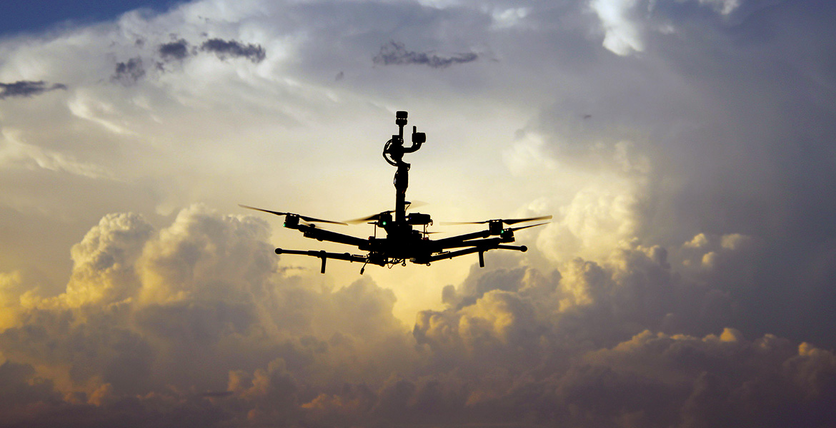
Dr. Jamey Jacob, director of the Unmanned Systems Research Institute, joined Oklahoma State in 2006, bringing with him a specialization in rotary wing aircraft such as quadcopters, which people typically think of as “drones.” Projects under his wing also include high-altitude kites and autonomous blimps, known as inflatable structures or soft goods.
“We’re doing new things other people haven’t even thought of yet,” Jacob said. “We’re pushing the envelope to develop concepts that may be on the field from two to 10 years from now.”
OSU’s new unmanned systems development center, Excelsior, opened last fall, providing a dedicated space for unmanned systems research including work with the environment, ecology, weather, climate change and national security.
“This exemplifies our philosophy of really understanding what we are doing,” Jacob
said. “(At many universities), you
end up with a lot of aerospace engineering researchers who focus on theory and not
practically implementing their ideas. Our hands-on focus gives us the capability to
do things for research programs and customers at the government and industry level
that other universities can’t do. We can go from a clean sheet of paper, design, build
and flight test an aircraft in a matter of months. Other universities do things on
paper, try to go out and buy something or rely on simulations.”
The USRI also employs full-time research engineers.
“It’s not just graduate students,” Jacob said. “While graduate students form the backbone of any university research program, they tend to focus on long-term, hard-to-solve research problems and don’t have the time to help out faculty or other graduate students to solve the time- sensitive problems. Our research staff can work with faculty, graduate students and undergraduate students across campus as well as external customers to provide innovative solutions with a very rapid turnaround time.”
Having research engineers with experience in specialties such as remote sensing or photogrammetry on staff puts projects ahead of the curve. Students spend less time figuring out what they need to do and more time involved in research itself, he said.
Enviromental Monitoring
Jacob has found drones are an efficient environmental monitoring tool, navigating areas that are hard to reach or measure. And not all unmanned vehicles fly. When studying water quality, small, autonomous boats can reach more remote areas than traditional methods.
“The boat goes out and takes measurements in the water and reports those back,” he said. “Traditionally, if you want to get water quality measurements, you put someone in a kayak, and they paddle out to get samples taking up time they could instead be using to analyze the data. At the end of day, it always comes back to data.”
OSU’s unmanned systems teams were crucial in monitoring the spread and the efficacy of the treatment of the Yellow Floating Heart invasive lily at Lake Carl Blackwell. Aquatic ecologists used satellite photos to measure the amount of the lake affected, but the photo quality and cloud cover made some calculations difficult. OSU’s USRI upped the game with a multispectral sensor that could photograph in five bands: blue, green, red, near-infrared and red-edge. Standard, off-the-shelf UAVs have only three.
“These extra bands enable better discrimination of YFH from native aquatic vegetation and value added products like percent canopy cover,” said Dr. Ranjeet John, an assistant biology professor at the University of South Dakota. “This UAV imagery also enabled validation of lakewide estimates of YFH derived from satellite imagery.”
Victoria Natalie, a research engineer with USRI and an OSU grad, is working with OSU’s geography and geology departments as well as the USDA, Department of Fish and Wildlife and the National Weather Service. She uses drones to take multispectral images to predict cotton and peanut yields. Another project with winter wheat measures plant height and creates a three-dimensional map. Natalie is using the 3D canopy model to measure crop volume under different nitrogen treatments.
“Measuring vegetation volume using traditional methods is a difficult task and needs extensive field sampling, which are expensive and limited in their ability to cover large areas,” said Dr. Hamed Gholizadeh, an assistant geography professor. “Drones can help us measure vegetation volume in time- and cost-efficient ways.”
For the Department of Fish and Wildlife, Natalie is mapping river connectivity as it relates to the endangered Arkansas River Shiner, a small minnow. The fish requires more than 100 miles of flowing river for its long-term survival, and it’s being affected by reservoir construction, which has broken up long stretches of river.
Drones are also changing the face of what’s possible on the front lines of first responses. After the 1995 Murrah Building bombing, the late Jon Hansen, the face of the recovery effort with the Oklahoma City Fire Department, said the building’s structural damage prevented the department from sending crews inside. He needed a way to assess the situation, search room to room and communicate with the injured.
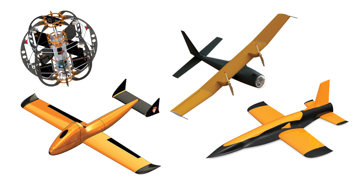
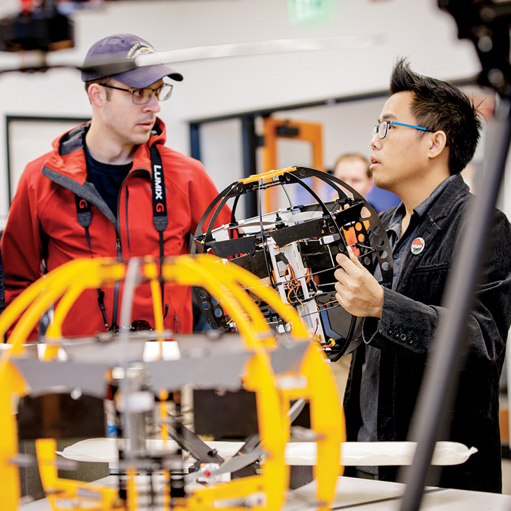
Dr. Ben Loh, USRI graduate and research engineer, created OSU’s All Terrain Land and Air Sphere (ATLAS), which is encased in a protective cage. Typical drones have exposed propellers and require a coordinated landing. If one turns over, it can’t right itself and take to the air on its own.
“With most aerial platforms, propulsion noise is always an issue if using a microphone to pick up the victim’s voice at a disaster area,” Loh said. “One way to overcome that is to land the aerial vehicle to stop the propeller. With something like the Murrah bombing scene, most exposed propeller platforms like a quadcopter can easily get caught by the debris or dangling wires in the building. A quadcopter without a prop guard could accidentally hit an obstacle and flip over. This could mean the end of the mission since it cannot recover to flight.”
Loh’s ATLAS design has a spherical cage around the aircraft, protecting the propellers from debris and people from the propellers.
“The spherical frame can endure an uncoordinated landing,” Loh said. “The cage allows ... ATLAS to roll away from obstacles and recover to flight.”
ATLAS is also designed to carry a payload specific to the mission, from cameras and carbon dioxide sensors to LiDAR, an instrument that uses pulses of laser light to build a complex three- dimensional terrain map. Loh also created a version with a foam-board cage that is an affordable option for STEM teachers in elementary and secondary education.
Another first response project couples OSU’s unmanned aerial system expertise with local startup MaxQ. Created by OSU grads, MaxQ is developing lightweight drone-delivery compatible packaging solutions. CEO Dr. Saravan Kumar said the containers make it possible to keep critical supplies such as blood, vaccines and medicines at precise temperatures to preserve lifesaving abilities. Jacob said they’re also working on a parachute system, testing for drop deliveries in battlefield applications.
Kumar said MaxQ is thrilled to be in partnership with USRI.
“Their expertise on unmanned systems and regulatory requirements has tremendously helped us shape this project. USRI’s facility and resources are top-notch,” he said. “Through this partnership, we were able to prototype and conduct demonstration flights for the drone-delivery packaging. Without this partnership, it would be incredibly difficult for us to proceed with this project.”
Forecasting Disasters
The applications of UAVs in natural disasters are also broad. UAS-gathered data can enhance forecasts, improving researchers’ ability to predict the direction and intensity of wildfires. In a wildfire, UAS can also be used to obtain an accurate map of the spread of the fire to prevent firefighters from being surrounded.
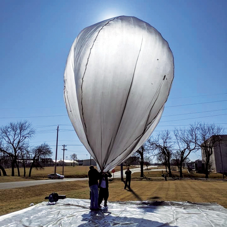
Jacob and his team will be using solar balloons this spring to send up infrasonic sensors in hopes of “hearing” the early stages of an earthquake. Dr. Brian Elbing, a professor in mechanical and aerospace engineering, and his team have developed a system of microphones that capture low- frequency sound or infrasound that will be used on the balloons.
“Earthquakes make noise below the level of human hearing,” Jacob said. “You can pick these up when the fractures below the ground start rubbing against each other.”
The USRI constructs its own balloons. When fully inflated, they’re as wide and tall as a dump truck. The insides are dusted with charcoal to turn the balloons black so they will absorb heat from the sun, which gives the balloons buoyancy.
“The benefit is that they stay aloft for a very long time,” Jacob said. “They use no fuel and can fly at very high altitudes, floating along with the currents of a developing storm where nothing else can fly.”
The Possibilites
The project with balloons has even loftier applications than predicting natural events and disasters.
“NASA’s Jet Propulsion Laboratory wants to check them for a future flight on Venus,” Jacob said. “What we are doing with them is using the fact that we have a lot of earthquakes here as a diagnostic tool to test interplanetary drones that will eventually fly on other planets such as Mars and Venus. That way, we can evaluate their interior geography using ultrasonic sensors. So Oklahoma essentially becomes a testing ground for these new sensors.”
It’s this way across the board. Perhaps Natalie said it best in calling the UAV landscape the “wild west of aviation.” From designing drones to helping the Army to improving first responses, natural disaster predictions and environmental monitoring, researchers have only scratched the surface of what is possible.
And Oklahoma State University is leading the charge.
“Everybody in the country, every university, will say, ‘We do drone research,’” Arena said. “They may work on the software. We do soup to nuts. We can design, fabricate, test, fly — everything from absolute scratch. There is no place that does what we do.”