One Dam Project
Monday, January 9, 2023
Media Contact: Kaitlyn Weldon | Digital Communications Specialist | 405-744-7063 | kaitlyn.weldon@okstate.edu
Nearly 90% of Oklahomans live within 20 miles of an earthen dam that affects their daily lives. As these U.S. Department of Agriculture-constructed structures near the end of their engineered lifespans, the time to take action is now.
The Dam Analysis Modernization of Tools, Applications, Guidance and Standardization, DAMTAGS, project is underway to take preventative measures to help dam safety.
In the 1940s and 1950s, the Midwest experienced significant flooding. Oklahoma was emerging from the Dust Bowl era, which left the soil vulnerable and susceptible to erosion. However, no dams existed at the time to hold back floodwaters.
“During that time, people began to see headlines about flood-related deaths in local newspapers,” said Sherry Hunt, research leader and acting location coordinator for the USDA-Agricultural Research Service agroclimate andhydraulic engineering research unit. “The headlines captured the attention of the Congressional delegation in Washington, D.C.”
In 1944 and 1954, Congress passed two acts to create the USDA Small Watershed Program, which led to the construction of nearly 12,000 flood-control, earthen dams across the country, including in Oklahoma.
“When people think of dams, they tend to think of the Hoover Dam, but these are small, earthen dams with an average height of 36 feet and a 50-year lifespan,” Hunt said.
More than 2,000 of these federally sponsored dams are located in Oklahoma, where they provide benefits foragriculture, energy production, recreation, urban areas, drinking water, healthy ecosystems and so much more, Hunt said. Oklahoma has more of these dams than any other state.
“It’s estimated these dams and reservoirs provide $2.4 billion in annual benefits,” Hunt said. “For example, people like to go out and enjoy the trails at Lake McMurtry. But, they don’t even realize all of the other benefits these structures are providing to the community.”
Sierra Schupp, who serves as the Oklahoma Water Resources Center outreach and communications specialist, said while the structures are safe, measures to preserve the aging structures can benefit entire communities in the future.
OWRC, an agency partner with OSU Agriculture housed in the Noble Research Center, empowers decision-making and spreads understanding through research, extension and outreach.
“Dams affect everyone,” Schupp said. “The interesting part about these dams is many people don’t know about them. How would they unless they see that dam daily?”
Many upstream flood control dams originally were built to protect crop-land, but with population growth and urbanization, they now also protect homes and communities in their areas.
“I’ve heard others refer to these dams as ‘silent sentinels’ because most people don’t realize they exist until they are needed,” Hunt said.
So far, researchers have focused on three dams near Oklahoma State University: Lake McMurtry, Boomer Lake and Lake Carl Blackwell.
“These dams are rather safe and provide a purpose, but they are aging just like buildings, roads and bridges,” Hunt said. “We just need to be more vigilant in making sure they are operating as intended.”
This preventive mindset is the premise behind DAMTAGS, Hunt said.
OWRC has partnered with the USDA-ARS and the USDA-Natural Resources Conservation Service to develop DAMTAGS. This five-year project combines research with cutting-edge technology.
DAMTAGS is in its second year, and researchers collect real-time data to get a better understanding of what is happening at these structures and in the water reservoirs to prevent future issues, Hunt said.
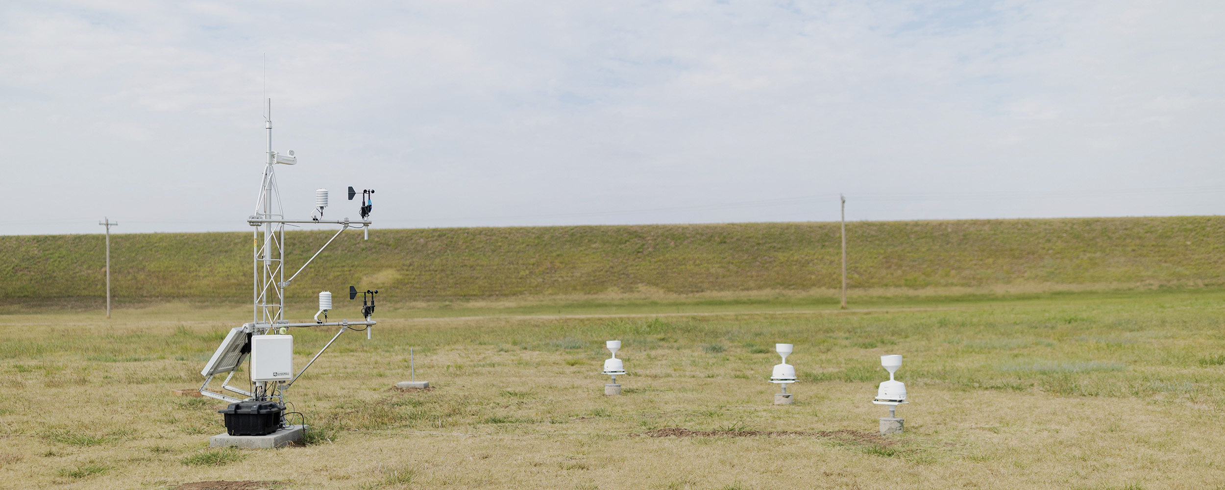
“One of our notable achievements right now is developing low-cost sensors that measure rainfall, wind speed, humidity, barometric pressure and soil moisture,” Hunt said.
Off the shelf, these sensors cost approximately $30,000, but USDA-ARS and other partners created a comparable sensor for $250, Hunt said. OWRC will help deploy and test the new sensors to compare their performance to the higher-priced sensor station.
“Hopefully, other agency personnel, watershed management groups and conservation districts will be able to take advantage of the new cost-efficient sensors to better monitor across entire watersheds,” said Tim Propst, OWRC scientific coordinator and technical writer.
Other technology has been a major success for the project, Hunt said.
“Our research unit scientists in collaboration with the USDA-ARS Partnerships for Data Innovations are testing a scientific unmanned aerial vehicle, or drone, named ‘Goose,’” Hunt said.
The drone is being used to take images and collect data about how a dam is performing to prevent future damage, Hunt added.
“Older methods may take an entire team several weeks to do the same kind of imagery and scanning the drone can do in hours,” Schupp said.
Schupp said using the drone to analyze dams helps researchers find weak points faster.
“It’s early on in the project, but we’ve brought the team together, established lines of communication, and done a lot of the groundwork,” Propst said. “What remains to be done is gathering the actual data.”
The DAMTAGS team is organizing all the data to make it accessible to various agencies, engineers and scientific technicians.
“It’ll be an important resource that can be used by multiple agencies,” Propst said. “NRCS engineers and technicians will be able to utilize the information to help determine if they need to upgrade or modernize dams.”
Propst said DAMTAGS is still pioneering how the data will be organized and what the infrastructure of the data uptake and analysis will look like.
“The more data you collect, the more applicable your results are,” Propst said.
The team is trying to stay on the cutting edge of technology and analysis to make the project as efficient as possible, Propst added.
“It’s been a steep learning curve at times,” Propst said. “A lot of this is engineering, and I’m not an engineer.”
Propst said the whole idea is to get information at the fingertips of decision makers. The OWRC has more work to do because time is critical as the dams age, he added.
“We have a responsibility to protect and steward our natural resources,” Propst said. “Water is arguably our most precious resource, and this project has a definite impact on water availability and allows us to take care of what has been given to us.”
The public needs to know the work is being done, Propst said, and they need to stay informed because whether you live on 10,000 acres or in an apartment, you live in a watershed.
“It’s kind of this bigger picture holistic approach where we can’t be experts in everything, so we have built a diversified team to work for a common cause so generations to come will continue to benefit from what these dams and impounded reservoirs provide,” Hunt said.
What on Earth is an earthen dam?
Simply put, an earthen dam is earth, composed of dirt, sand, gravel or other earthen materials.
For centuries, humans have successfully used these basic materials to help control the flow of water. In fact, some earthen dams constructed by the Romans in the first and second centuries remain in use.
Although the materials and techniques are now more refined, the concept of layering and compacting these components to produce an embankment capable of retaining water is used today.
These earthen dams include the vast majority of the structures produced in response to U.S. flood control legislation in the mid-1900s, which are the focus of the Dam Analysis Modernization of Tools, Applications, Guidance and Standardization project.
Source: Oklahoma Water Resources Center
Story By: Reagan Glass | Cowboy Journal