
OSU's high-speed drone tackles study of severe weather
Thursday, May 14, 2020
With dark clouds encroaching on OSU’s Unmanned Aircraft Flight Station, a group of researchers prepares to fly a drone directly into a foreboding storm ... in the name of safety.
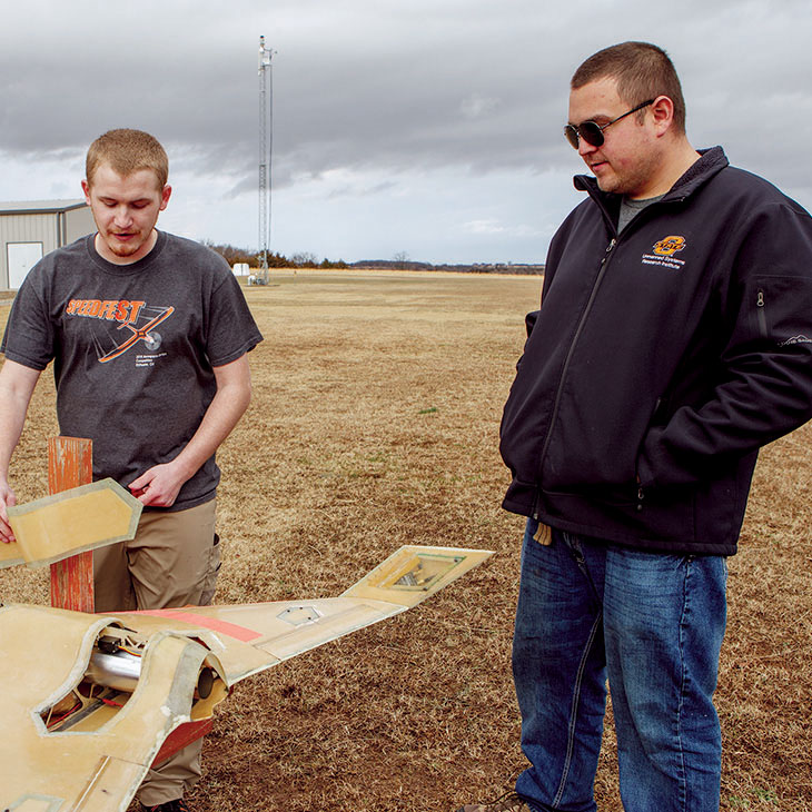
Few pilots would intentionally draw up such a flight plan, but the Tornado Intercept Aircraft (TIA) is designed to penetrate storms, withstand the tempest and return with groundbreaking data.
“We’re focusing on going places traditional unmanned aircraft can’t,” said designer and project lead Levi Ross. “It’s a very exciting aircraft and it does what most Unmanned Aerial Systems cannot do.”
There’s still more work to be done, but Ross said his team is building a system that he hopes storm chasers and meteorologists will someday trust to gather better data to improve weather models.
The TIA project is just one facet of the Tier 1 Drone Initiative’s exploration of how drones can address safety and environmental challenges.
OSU Vice President for Research Dr. Kenneth Sewell said the initiatives aim “to tackle some of society’s challenges head-on,” and the TIA project is a somewhat literal embodiment of that vision.
The project speaks to Oklahomans’ noted fascination with weather phenomenon and the advancement of technology and methods that could improve severe weather forecasting and save lives. And it’s not the only one of its kind taking off at OSU’s new Unmanned Systems Research Institute lab, dubbed Excelsior at its grand opening last November.
Real Measurements
Together, it all adds up to a better understanding of severe weather, and that makes it highly practical for Oklahomans and potentially everyone who finds themselves in the path of a storm.
“It all boils down to how well you can actually measure what the atmosphere is doing right now,” said Unmanned System Research Institute Director Dr. Jamey Jacob. “The more data you get, the better your forecast is going to be. Measuring the atmosphere is the real focus of our project — to be able to get enough data and feed that to the meteorological community ... such that you can not only predict if a tornado is going to happen, but you’re going to be able to forecast it with enough fidelity that you’ll be able to say ‘Hey, in an hour, you’re going to get a tornado in this region, and it’s going to be an EF-3, and it’s going to last for a five- mile tract.’”
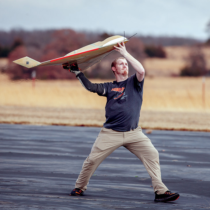
The craft has a 44-inch wingspan, weighs a mere 18 pounds and can reach speeds over 150 miles per hour thanks to its turbo-jet engine.
And its stealth bomber-inspired design makes it perfect for “punching through” squall lines.
The drone had successfully flown many times before, including placing second at OSU’s Speedfest in 2017. But the latest tests have it flying through heavier rain. Large aircraft undergo much testing to gauge how much water they can handle, but that’s not always the case for smaller craft.
“We’ve flown through light [rain],” Ross said. “Now we’re testing this water-shielding material to see if we can keep water from interfering with the aircraft’s components. We’re also testing how much water can go through the turbine, to determine what conditions we can fly in and what will be too much and choke out the engine.”
The TIA has no landing gear, which also plays to its advantage, allowing it to carry more weather-measuring instruments and to take off from the top of a modified OSU storm-chasing vehicle or even a researcher’s outstretched arm.
“The end goal of this aircraft is to be able to fly it through severe weather and get data — temperature, pressure, humidity — that meteorologists are trying to track,” Ross said.
Specific data from within
Of course, instruments already exist that measure those data points, but meteorologists seeking a clearer picture of the storm need data from within.
“Normally, weather measurements are gathered by weather balloon, but if I launch a balloon, it’s going to go wherever the wind takes it. ... If I can take a jet and put it in an exact location at a specific altitude, we can give scientists the exact data they’re looking for — what the temperature, pressure and humidity is at a specific spot,” said researcher Dane Johnson.
That directly translates to better and more cost-effective forecasting.
“This can be done with other aircraft, such as a manned aircraft, but the cost of running that manned aircraft for a single day is more than all the money we’ve spent on this entire aircraft,” Johnson said. “We can produce these aircraft for significantly less money, and there’s no reason to put helicopters or manned aircraft in the air. It means less risk on human life and more data.”
With a custom-made fiberglass shell, the TIA can withstand much higher wind speeds than most drones. It also has a higher top speed, besting its foam counterparts by about 50 mph.
While the Excelsior team has to keep the craft within the line of sight, due to FAA regulations, the ability to launch the craft from the top of a storm-chasing vehicle and follow it allows for swift response times and timely, informative data gathering.
The work of researchers like Victoria Natalie also plays into projects like the TIA. She studies how wind and weather interact with topography. Jacob said bringing all of the research together gives a fuller picture.
Meteorologist Trust
National Weather Service meteorologist Steve Piltz is familiar with the TIA project. Jacob and Piltz first met when Jacob discovered there was a meteorologist in Tulsa who happened to be a drone hobbyist. Since then, Piltz has provided Jacob and his team with guidance from a meteorological perspective. In short, he’s guiding them toward what meteorologists need.
Piltz said there’s no doubt the TIA is an ambitious project, but after nearly a decade of seeing OSU research in action, he is confident Jacob’s team can deliver.
“Having watched them work over the last eight years, they’ve always hit their mark.”
“While it won’t be easy, I think they can do it,” Piltz said. “It might not happen overnight. ... Even if we don’t get the full-blown, dramatic intercept of a tornado, being in the area and making those measurements still might lead to the collection of important data.”
When they do deliver, Piltz said, OSU’s research could mean the next big leap in severe weather study and forecasting.
“It could help us understand how tornadoes are formed and give us a better understanding of what we’re seeing on radar,” he said.
That, in turn, shapes how meteorologists relay information to the public.
“Every little step you can take to make your message a little smarter to the public, it’s a big deal really, especially in Oklahoma ,” Piltz said. “[Oklahomans] hear so much about severe weather. If we can key in on those days where they really need to pay attention, that helps. Any number of days have tornado potential ... but if we can save our high-end language for the truly high-end days, we'll get a much better public safety reaction, and everyone will be much better off.”
Piltz said there’s not much more meteorologists can do with radar than they’re already doing. Advancing the science of weather forecasting will depend on getting more data.
“The sexy stuff is we’re going to fly these near tornadoes, but more importantly, it’s about getting that data, the stuff you can’t see,” Jacob said. “There’s a lot that you get today from satellites, ground towers and radars. They represent a paradigm shift dating back to the mid-80s changing how we predict severe storms. We believe using drones in this way will be another paradigm shift in capability.
“Most of your predictions today are coming from two different things: the ground network — and Oklahoma has the benefit of the most advanced ground network in the world — and weather balloons. We have only one location in the state that launches weather balloons — and only two a day — and that’s where we get all of our observations about the upper atmosphere. That’s the stuff that meteorologists are really craving, because it tells them what’s going on aloft. It provides profile from the temperatures, and tells them how much energy is actually within the atmosphere.”
Jacob said that can help meteorologists answer the big question that hangs in the minds of Oklahomans as the storm presses toward them:
“Is the cap going to blow?”